Expectations: At each
stop on this trip you will make simple observations that are intended to
enhance your awareness of patch or stand and landscape scale ecosystems
and their variability. Additionally, you will be asked to speculate about
why some phenomena occur. You will need to know a few easy-to-learn
trees to complete this field trip. A very simple key to these species is
attached at the end of this document. Also, a brief classification of vegetation
zones of the Rocky Mountains follows the key.
To get there: Go northwest of Fort Collins on U. S. Highway 287 to the junction with State Highway 14 (Ted's Place). Turn west on State Highway 14 and set your odometer at 0.0.
Go 26.1 miles to the Pingree Park turnoff. Turn left onto the Pingree Park Road.
Follow the Pingree Park Road for 4.2 miles (mile 30.3) to the Crown Point Road turnoff. Be careful on this section of road -- it is steep, gravely and washboardy. There are no rail guards and the bottom is a long way down.
Turn west (right) onto the Crown Point Road.
Follow it 11 .7 miles (mile 42.0) to the Browns Lake Trailhead. Park
here in the trailhead parking lot.
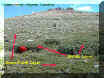
| Hike about 2 miles up the Browns Lake (Crown Point) Trail. You will abruptly (relatively) break out of the forest and you will be in a mix of Krummholz and alpine tundra. You are at the starting point of the field trip. This is a view looking east from the trail. |
|
Guide to stations for the
field trip:
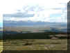
Stop 1. Hike up to the top of this ridge.
What do you see as you look
to the east from the top?
|
|
Look at one of these tree islands. What
species make up this tree island?
|
 |
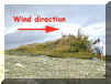
| Why do you think these plants and "tree
islands" have their present appearance?
What besides the direct effects of wind is involved in this sculpturing? |
 |
Stop 3. Return to the trailhead parking lot.
How many species of trees occur in the immediate area (100 m) of the parking lot?
What are they?
What is the position on the landscape of the parking lot (north, south, east, west, NE, SE, SW, or SE facing slope, ridge top, bottom land)?
Describe the understory vegetation?
Roughly describe the surface of the soils in this area.
Stop 4. Set you odometer to 0.0. Go back
down (to the east) the Crown Point Road (the same way you came up) 0.35
miles. Stop in a safe place and observe the ecosystem on the right (south)
side of the road.
| What tree species occur here?
Describe the position on the landscape of this ecosystem. |
|
Describe the understory layer (dominantly Vaccinium sp.)?
|

|
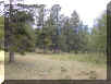
Stop 5. Proceed 2.4 miles (mile 2.75) down
the road. Observe the ecosystem on the north side of the road.
What tree species occur here?
|
|
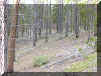
Stop 6. The next stop is 0.35 miles down
the road at mile 3.1. Observe the stand on the south side of the road.
What tree species occur here?
|
|
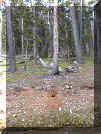
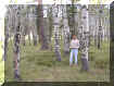
Stop 7. Continue down the road another 1.8
miles to mile 4.9.
Describe the vegetation and debris in this open patch. What caused the patch?
|
|
Stop 8. Move on 1.5 miles (mile 6.4) and
observe the stand on the north side of the road.
What tree species occur here?
|
|
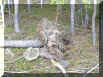
Stop 9. Go another 0.55 miles (mile 6.95)
and observe the ponds of water in the stream bed on the right side (south)
of the road.
What caused the ponds?
|

|
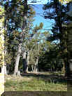
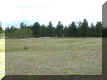
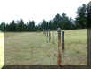
Stop 10. Continue another 4.65 miles (mile
11.6) down the road to the junction with the Pingree Park Road. Turn
right! Go 2.15 miles (mile 13.75) to a small road
that goes east (left) to an aspen stand a few hundred feet (< 100 m)
away. Stop at this junction. Look at the landscape as a whole in this area
and the observe each patch and answer the following questions for each
patch. Obviously one of the patch types has no trees!
What tree species occur in each patch?
|
|
Walk in the aspen stand?
|
|
Walk in the Ponderosa pine stand?
|
|
Walk in the vegetation on both the inside and outside of the fenced area?
|
|
Return back down the Pingree Park Road to
the Intersection with Hy 14.
Be Careful on this Road! At the intersection
reset your odometer to 0.0. Turn right and head back to Fort Collins. Go
5.85 miles to the Narrows Campground.
Stop 11. This is your final stop! Look
down canyon to the left side of the road. On the steep sides of the canyon
you will see one slope the is completely forested and opposite it a slope
that has no trees at all.
| What is the cause of this contrast? |

|
Go home! Your done. Good job! Thank you for your efforts!
Dr. Ecos
Attachment -- Key to tree species
Pinus flexilis = limber pine
P. contorta = lodgepole pine
P. ponderosa = ponderosa pine
Abies lasiocarpa = subalpine fir
Picea pungens = Colorado blue spruce
P. englemannii = Englemann spruce
Adapted from William A. Weber's Rocky Mountain Flora the major vegetation zones of the Rocky Mountains are:
Alpine tundra - 3,400 to above 4,000 meters altitude. Above timberline; no trees, mostly deep-rooted mat- and cushion- plants, dwarf willows, grasses and sedges. The grassy slopes are usually referred to as alpine meadows, to distinguish these areas from the more rocky fell-fields or boulder-fields.Subalpine - 2,700 to 3,400 meters altitude. Englemann spruce, subalpine fir, and limber pine forests interspersed with moist meadows, ponds, and bogs. Very rich in wild flowers.
Montane - 2,500 to 2,700 meters altitude. Lodgepole pine, Englemann and blue spruce, Douglas-fir, aspen and ponderosa pine. This zone is in many ways transitional between the foothills and subalpine. In many places in the Front Range this zone and the lower elevations of the subalpine have nearly pure stands of lodgepole pine.
Foothills - 1,800 to 2,500 meters altitude. Mountain mahogany at lower elevations, ponderosa pine dominates above, mixed with grassland; Douglas-fir in the north-facing ravines, and thickets of broad-leaved trees and shrubs alone the streams. Sometimes the upper elevations of this zone are called lower montane, making the montane (above) the upper montane.
Tundra 1
Tundra
2
Subalpine (spruce-fir)
Limber pine
Lodgepole
pine
Lodgepole
pine clearcut
Blue spruce
Ponderosa
pine
Mixed forest
Foothills
- mountain grassland