By Cara Steger
For two weeks in March 2017, I traveled to the north central highlands of Ethiopia to conduct a series of participatory mapping workshops with nine groups involved in managing a community conservation area. My field work had been postponed twice already due to civil unrest throughout the country, so I was fairly anxious right up until I arrived at the Guassa Community Conservation area with two research assistants and a whole lot of hope. Unfortunately, my anxiety only changed direction at that point, but we’ll get to that in a minute. First, some context:
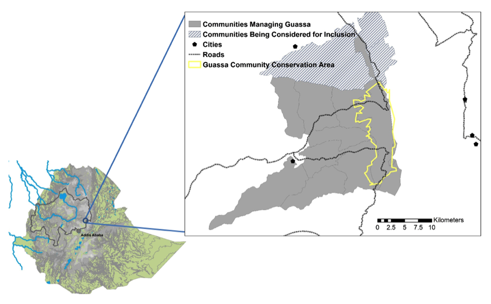
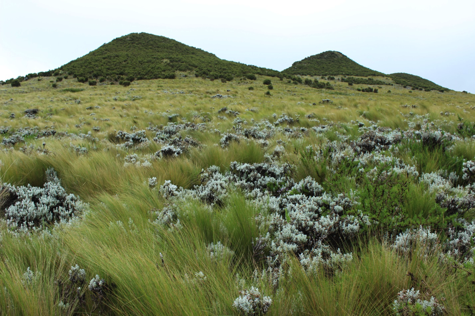
Guassa is a high-altitude (3200 to 3500m asl) Afro-alpine grassland named after four species of Festuca grass (guassa grass) that are highly valued by local people for their use as thatch, rope, construction material, and forage. It is also one of the most beautiful places I have ever seen, especially during the rainy seasons from May - October. Actually, you can read more about the wildlife found there in this month’s issue of National Geographic.
The area has been managed by the people living around it for nearly 400 years, though changing political structures have resulted in a significantly different modern governance arrangement from the traditional “Qero” system. The Qero system was a unique system of bylaws upheld by community enforcement through sanctions and punishment, aimed at regulating the supply of the guassa grasses. In 1974, the Communist regime transferred all land ownership to the state, which reduced the communities’ ability to exclude outsiders from their communally owned and managed system. The management system slowly unraveled between 1974 and 1999, though it never disappeared entirely, and in 1999 it was reinvigorated by international interest in the area through the PhD research of Dr. Zelealem Tefera Ashenafi and his affiliation with the Frankfurt Zoological Society (FZS). Dr. Ashenafi and FZS started an eco-tourism project in Guassa that channels all proceeds directly to the affiliated communities, with the aim of supporting public works projects like building roads, schools, and water pumps. [As of 2017, no public works projects have been funded through this mechanism, and the community seems hesitant to actually spend any of the money.]
The current management system is a collaboration between nine kebeles (the smallest administrative unit in Ethiopia), each consisting of approximately 3,000 - 5,000 people in roughly 20 -30 villages per kebele. Each kebele nominates five people to the Guassa Committee, plus one more to sit on the Tourism Board – which serves as a sort of executive committee for the area. A Guassa Conservation Office was recently installed by the regional government to provide ecological and economic council to the kebeles following the 2012 proclamation that officially returned land ownership to them. Additionally, the local woreda (similar to a county) administration provides council to the Guassa Committee and Tourism Board, and their authority is separate from that of the Guassa Conservation Office. In short, it’s complicated.
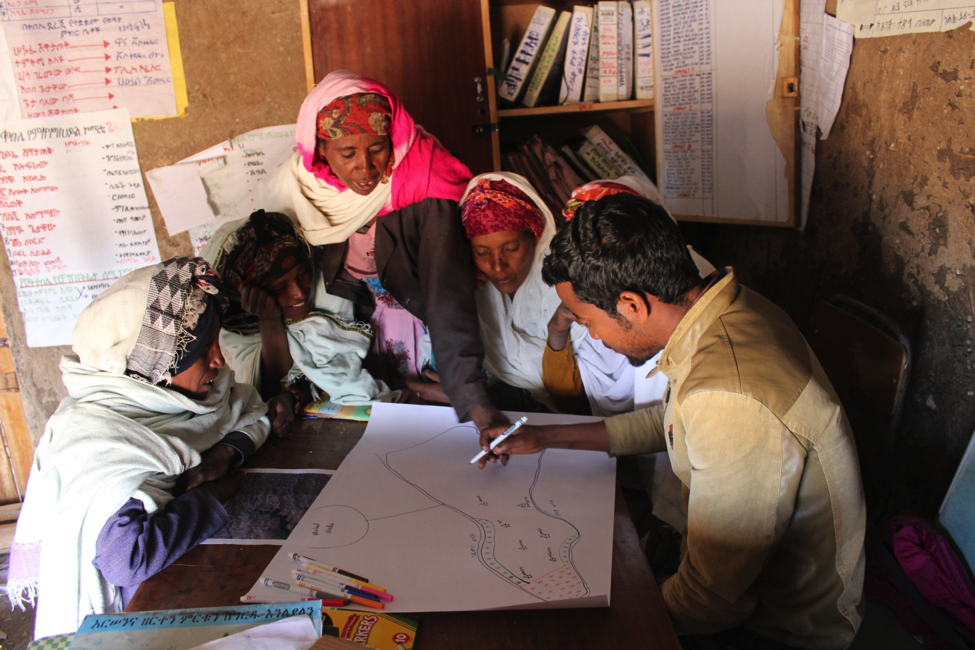
Participatory Mapping
I originally conceived these participatory mapping workshops as a way to introduce myself (and geospatial methods) to the kebeles, and to learn more about their perceptions of the environment. The workshops were organized into three main parts: (1) a group discussion around land use/ land cover (LULC) groups and their associated ecosystem services, (2) small group mapping of those LULC groups, and (3) a group discussion of changing LULC in the area, with explicit attention to community interpretations of remote sensing images. The idea was to get people comfortable talking about LULC in locally relevant ways, then ask them to describe LULC distributions to me by drawing a map, and then discuss how those distributions have changed since the days of the traditional Qero system of management.
I had meticulously planned for these workshops by reading extensively, developing prompts to facilitate discussions, gathering diverse types of materials to use for mapping (e.g., markers, stickers, blank maps, satellite images, aerial photos, etc.), and preparing unsupervised classifications of Landsat images to guide our discussions of historical trends in LULC. I spoke with several researchers who have conducted this kind of work – some of them in the same region of Ethiopia! – and reviewed and revised my protocols according to their advice. I was ready.
After the first workshop I threw much of that protocol out the proverbial window. To be fair, parts 1 and 3 of all nine workshops exceeded my expectations – people were quite energized when talking about and debating ecosystem services and their relative importance, and they especially loved connecting their historical knowledge of the system to the classified Landsat images once I had explained them a bit. But the hand-drawn mapping caused significant consternation among both men and women (who mapped independently), and I have a few ideas why that is:
Scale and Orientation
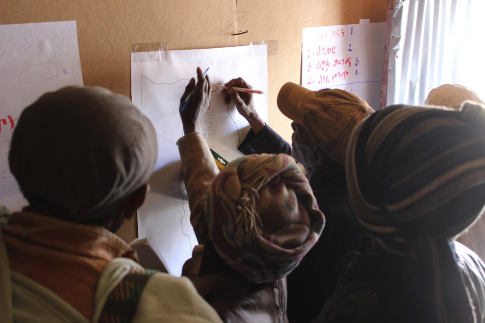
I first asked participants to draw a map of the general area, including all nine kebeles and Guassa (~ 800-1000 km2). I knew from the literature that this was probably too large an area for people to draw accurately, but I thought it would provide good insight into the ways each kebele conceives of the others. My research assistants and I tried to facilitate mapping at this scale by pointing to and explaining major landmarks like cities, roads, and the escarpment that runs along the eastern and northern edges of the area, but nothing seemed to click - even when we aligned the paper map with the cardinal directions in real space and asked people to point to where those features were (which they did with no problems). It was clear that there was some mismatch between Western-style mapping and the ways they conceptualize space and orient themselves in it.
We then tried bringing out aerial photos of the region (taken from Google Earth), and connecting the points and lines of the simple map to the cities and roads seen on the photos, but this too didn’t seem to clarify anything. It eventually emerged that many of the participants had never even seen a map before, and that they were entirely unfamiliar with the idea of looking down on the world from a bird’s eye view. I’m still not sure why it took so long for that to come to light, but I imagine participants were hesitant to tell us in case we cancelled the workshop (we paid them each ~$2 for their time, which is a decent wage in that area). During the exit interviews, several participants told us they would be more comfortable mapping at the scale of the kebele, which they knew very well (~30-70 km2). So the next day, we drew a rough outline of the kebele we were in and asked them to use that to guide the mapping, which helped considerably.
Literacy and Drawing
In the second workshop, participants protested that they were unable to sketch the maps themselves due to literacy barriers and drawing ability. The women in this workshop told us that because they were all illiterate, they could not draw a map. They proposed a compromise: if the research assistants were willing to actually draw and write on the map, then they would guide the placement of the features. This new arrangement solved some of our problems, but brought with its own set of challenges, including relying heavily on my research assistants’ abilities to draw and reason spatially. My assistants were highly educated, but they differed considerably in their ability to sketch and draw objects at the same scale – one was very good, and the other was only marginally better than the participants from the first workshop.
This experience convinced me that literacy is not a barrier to participatory mapping in and of itself, but it became a barrier in this situation because the participants decided it was one. There is undoubtedly some connection between literacy and drawing ability in the sense that fine motor skills are needed in order to hold and use a marker or pencil, but literacy does not guarantee the ability to draw a map. Participants may have used literacy as an excuse because they were intimidated or uncomfortable with the entire mapping process, when in reality the barriers might be more along the lines of individual spatial reasoning, enthusiasm for the process, and artistic talent.
Moving Forward
In conclusion, my field work evolved in ways that I had not anticipated, but which yielded some useful insights for future applications in participatory mapping. In particular I struggled with the realization that the local knowledge of the system was being filtered through multiple channels on its way to me: first it was conveyed verbally to the research assistants in Amharic, who translated it into symbols that they placed on the map according to their own interpretation of space, which they then verbally described to me in English. This multi-layered filtering, along with the imposition of Western-style mapping/orientation, leaves me questioning whether participatory mapping would ever be an effective method of accurately depicting local knowledge of this system.
However, it was encouraging to realize that the community members did not object to maps in general, as they enthusiastically participated in part 3 of the workshop. Men seemed more comfortable than women explicitly engaging with the maps, pointing to particular colors or locations and speculating on what they might represent in reality. It is unclear whether the most active participants were already somewhat familiar with maps, or whether our four-hour workshop was sufficient to make them comfortable discussing (but not drawing) them. I am not quite ready to write off participatory mapping as a method for my work, but I plan to take my next steps much more cautiously and with a greater appreciation for social and cultural differences in the conceptualization of space.
Cara Steger is a PhD student in the Graduate Degree Program in Ecology. She is a human-environment geographer with a regional specialization in Sub-Saharan Africa and growing technical expertise in geospatial technologies, environmental modeling, and collaborative approaches to conservation. You can learn more at her website (carasteger.weebly.com), and she’s generally not far from the Twittersphere: @carasteger.
This work was supported by the Rufford Foundation (http://www.rufford.org/) and by National Science Foundation IGERT Grant No. DGE-0966346: I-WATER: Integrated Water, Atmosphere, Ecosystem Education and Research Program at Colorado State University.![]()
Connect with EcoPress on social media, like us on Facebook and follow us on Twitter, @nrel_science, for the more stories and news.