Across the world, access to safe, reliable supplies of freshwater is being threatened by overexploitation and contamination of streams, lakes, and aquifers, particularly near urban metropolises and areas with dense agricultural production.
Water security is a state where everyone has adequate access to water that is safe from water-borne pathogens and pollution,and where ecological systems that depend upon clean freshwater are protected
Introduction
About 3.5 billion years ago water first appeared on earth, and soon after, the first lifeforms. The human body is more than 70% water; we cannot survive without it, nor can our crops or livestock. But our blue planet, ironically covered by oceans, holds scarce supplies of clean, freshwater, and ecosystem processes that support the natural cycle of freshwater are under pressure. Water scarcity is increasing around the world due to overexploitation and contamination of streams, lakes, and aquifers, particularly near urban metropolises and areas with dense agricultural production. From Los Angeles to New Delhi, cities in arid climates struggle to meet the water demands of growing populations. Agriculture and industry threaten to overdraw aquifers and contaminate surface water, and conflicts are intensifying between urban and agricultural water demands. Communities, businesses, states and countries worry about how their neighbor’s water use may threaten their water supply. Without a doubt, water security will be a core natural resource challenge for years to come, requiring technological innovation, ecological conservation, and political negotiation, informed by robust scientific research.
Water security is a state where everyone has adequate access to water that is safe from water-borne pathogens and pollution, and where ecological systems that depend upon clean freshwater are protected. Water security includes issues of public versus private access, regulation and enforcement of water quality, and delicate social-ecological compromises to maintain the sustainability of the water cycle from rain drop to replenishment of ancient aquifers. At NREL we use a combination of cutting edge physical, chemical, social and ecological field studies, information from satellites, and mathematical models to evaluate how distributions of freshwater resources are changing and how the implications of these changes impact natural systems and human communities around the world. This includes seeking to understand how large lake ecosystems support a diversity of human livelihoods, how pollutants and nutrients move through watersheds, how the frequency and intensity of snowfall and rain are being altered by climate change, and how the water cycle responds dynamically to human and natural changes over time. Because of our breadth of disciplines and an environment that fosters interdisciplinary science, NREL is uniquely positioned to address the most pressing aspects of water security.
The impact of a changing climate on variability in the water cycle
Dr. Steven Fassnacht is working with CSU students to examine how different ecological features and environmental drivers vary over space and time and are impacting the water cycle. The presence of a changing climate makes us realize that past conditions may not serve to predict future conditions. The earth is experiencing more extreme weather and greater variability, both from year to year and across regions. This fundamental research examines how the earth's climate is changing, how we quantify extreme changes such as devastating drought or flood conditions, and how these extreme events may influence water resources and water availability. Graduate students are actively involved, leading data collection and mentoring undergraduates through CSU’s Vertically Integrated Projects Program. Students collect data on snowpack, soil moisture, temperature and precipitation, learning sampling strategies for
measuring and ground-truthing these variables using remote sensing, modeling, and other information.
While much of Dr. Fassnacht's research focuses on physical hydrological systems, biophysical models often neglect the fact that data collection is imperfect and imprecise, and do not explicitly address the implications of this uncertainty. There is uncertainty and variability within the spatial and temporal resolution of data, which can lead to questions about how representative models are of the real world, and influence the reliability of extrapolation to predict future outcomes. To address this ubiquitous dilemma, social and ecological data are being combined to help define the variability of the hydrology data collected by Dr. Fassnacht’s group.
Modeling snowmelt from mountains,
our natural reservoirs
A research group led by Dr. Stephanie Kampf is exploring streamflow generation from permanently snow covered mountains. Mountains collect snow and serve as natural reservoirs, slowly releasing water to lower regions of continents and distributing water more evenly across seasons. Her research team is examining snow loss across diverse mountain landscapes around the world, using satellite data from the MODIS sensor to map snow patterns, and monitoring watersheds. They are able to track how pulses of snowmelt move from the landscape into the soil and streams and to the human populations downstream that depend on them. “By linking this information with streamflow data, we are developing methods for predicting streamflow in areas that do not have as much hydrologic monitoring as we do here in the US,” explains Dr. Kampf. The results of this research can help inform water supply and land-use planning, critical issues for communities in the Western U.S. and other arid areas around the world dependent upon snowmelt.

Mapping the mighty Colorado River
Dr. Paul Evangelista and junior NREL researchers have endeavored to map all riparian corridors within the Colorado River Basin in the Western United States. This enigmatic watershed, which covers 400,000 square kilometers of iconic deserts, canyons, and mountains, supplies water for some of North America’s fastest growing urban areas and irrigation for millions of acres of intensive agriculture in the arid Western United States. Using remote sensing (satellite) data, researchers are classifying riparian vegetation, including invasive species, and using these data to understand geophysical changes throughout the region. One of the team’s primary focuses is mapping a thirsty invasive willow species called Tamarask that increases evapotranspiration rates and water loss from the soil to the
atmosphere. In turn, this reduces the streamflow and water availability for agriculture and municipalities. Dr. Evangelista’s research team is interested in determining how remote sensing can be used to map and monitor water security and impacts to streams. “Significant investments have been made toward mitigation treatments for Tamarask, but the effectiveness of these treatments is unknown,” reports Dr. Evangelista. Detailed spatial data are needed to track how effective invasive plant mitigation strategies have been and will be over time. This extensive map, crossing seven states and fifty Landsat satellite regions, would serve as a baseline from which to evaluate future human induced changes.
Wildfires threaten water security
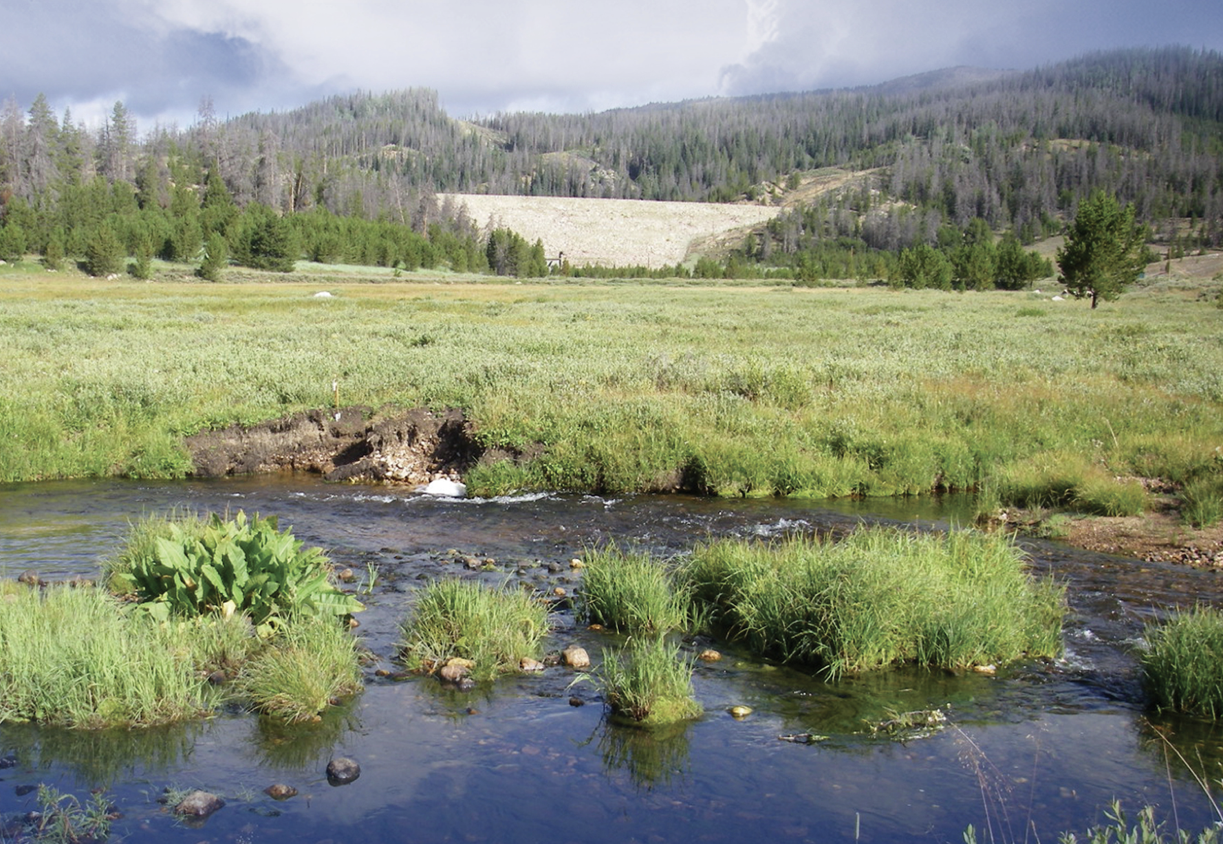
Wildfires are a perennial concern for communities in the Western U.S. Fires create expensive water filtration problems for water utilities. In collaboration with other researchers at NREL, Dr. Kampf’s team has been studying the area of the 2012 High Park Fire, which occurred near Fort Collins, Colorado, to understand the consequences for hillslope erosion and effects on stream channels. The High Park Fire was the second-largest wildfire in Colorado history, burning around 87,000 acres, and destroying more than 250 homes, and this massive loss of forest and groundcover contributed to the catastrophic Colorado floods in 2013. Student researchers working with Dr. Kampf collect rainfall, eroded soil, and stream flow measurements to determine what types of conditions increase erosion and delivery of eroded sediment to streams. As the landscape gradually recovers from the fire, researchers track vegetation growth, streamflow, and stream water quality. By understanding how long effects of fires persist and determine whether the landscape and streams have long-lasting changes, water resource and forest managers can work together to prepare for fires and mitigate their impacts upon our water supply.


Aquifer sustainability
Aquifers are a major source of water in semi-arid and arid regions around the world. In Turkana County of northern Kenya, along the border with South Sudan, the discovery of two large aquifers has led scientists to estimate that deep groundwater resources may be able to satisfy the region’s water needs for the next 70 years. To better understand the time horizon of water supply from these ancient aquifers, Dr. Stacy Lynn and her research group are performing a multi-disciplinary analysis assessing historic water access and use in Turkana. The group of social-ecologists are looking at the spatial and temporal distribution of water sources with respect to settlements, water-related challenges faced by communities, and the water governance history throughout Kenya. “We are using this system to test if water use decisions in rural Kenya may move the landscape from a non-equilibrium to an equilibrium system,” explains Dr. Lynn. “We want to know how the burdens and benefits of water development scenarios are distributed regionally among stakeholders.” In turn, Dr. Lynn will be able to provide a more precise estimate on the time horizon of the water supply for these aquifers, and better inform the communities for long-term planning in the region.