EcoPress Interview: Steve Chignell, a Master’s student in the watershed science program in ESS, has been on a number of projects and is currently the Assistant Center Lead for the NASA DEVELOP program hosted at NREL. NASA DEVELOP is an “interdisciplinary research environment where applied science research projects are conducted under the guidance of NASA and partner science advisors;" the program at CSU is headed by Dr. Paul Evangelista of NREL. Steve joins EcoPress for the first time to discuss DEVELOP.
NASA DEVELOP is currently accepting applications for the Spring 2015 term. The application for the Spring 2015 term is open until November 7, 2014. Check it out here! For more information on applying, see the contacts at the bottom of this post.
Welcome to EcoPress Interview, Steve! To begin with, tell us a little bit about the NASA DEVELOP program, the goals of the national program, and what is happening locally in the Fort Collins node.
Thanks for having me!
DEVELOP is a research and training program under NASA’s Earth Science, Applied Sciences Program. NREL hosts one of 13 DEVELOP locations in collaboration with the U.S. Geological Survey Fort Collins Science Center. The Fort Collins “node” fosters interdisciplinary research where undergraduate, graduate students, and young professionals receive training and hands-on experience working with scientists and natural resource managers utilizing NASA Earth observatory technologies to address community concerns and public policy issues. Each Fall, Spring, and Summer term, teams conduct an intensive 10-week project that includes literature review, research, and hand off of a number of deliverables. Additionally, the program has a strong emphasis on collaboration, and each team works with one or more partner organizations from the beginning of a project to the final hand-off of results.
Who are some of the local project partners DEVELOP has worked with recently?
Because we are uniquely situated at both an academic and federal organization, we are able to connect with scientists and land managers at both the local and national scales. Recent partners have included the North Central Climate Science Center, the Geospatial Centroid at CSU, the Colorado Natural Heritage Program, the US Forest Service and USAID.
What are the main learning objectives for a DEVELOP participant? What can participants hope to learn and take away from a semester working in the program?
Participants learn a number of technical skills, including being able to acquire, process, and analyze multiple types of remote sensing data, and how to integrate these data in correlative spatial models such as MaxEnt. We engage in trainings with advanced modeling software and spatial analysis in ArcGIS and ENVI. The CSU node also places a strong emphasis on fieldwork—especially in the summer term—and teams often spend 1-2 weeks of the term collecting GPS points and plot data within their study site.
Participants learn a number of technical skills, including being able to acquire, process, and analyze multiple types of remote sensing data, and how to integrate these data in correlative spatial models such as MaxEnt.
Each team is required to create and hand off a number of deliverables throughout the duration of the term. These include a comprehensive technical report, explanatory video, PowerPoint presentation, and poster. Through the creation of these deliverables, participants employ a host of skills from literature review and scientific writing to recording/editing film and scriptwriting.
Results are regularly presented at both national and international professional conferences, as well as local and CSU- sponsored symposia and seminars. This gives DEVELOP participants the opportunity to practice sharing their work with both the larger CSU network and scientific community.
What are some of the past projects to come out of the Fort Collins node and what are the projects this semester?
The CSU node has worked on a number of local and regional projects that include:
- Quantifying Pine-Beetle Mortality in Colorado’s National forests
- Modeling wetlands in the Cache la Poudre watershed
- Mapping the extent of the 2013 Colorado Floods
Projects outside of Colorado include:
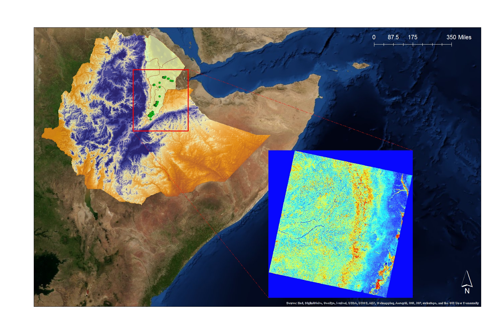
- Predicting invasive species distribution in both Alaska and Ethiopia
- A current project with the USGS to map distribution of invasive tamarisk in Havasu National Wildlife Refuge, Arizona using Unmanned Aerial Vehicles (UAV).
Can you direct our readers to some deliverables from recent projects?
Abstracts and videos for all previous projects are available online at: http://www.earthzine.org/develop/. Here are a couple that EcoPress folks might be interested in:
“Landsat 8 and MODIS: A Powerful Duo for Invasion Risk Assessment in Alaska”
[youtube https://www.youtube.com/watch?v=kmLUkOCgDU0&w=560&h=315]
“Utilizing Landsat and Statistical Models for Mapping Wetlands in Northern Colorado”
[youtube https://www.youtube.com/watch?v=O2pHI9Z0D0I&w=560&h=315]
On a more personal level, can you talk a little about what DEVELOP has meant to you and how it has helped you develop professionally?
My advisor connected me to the NASA DEVELOP program in the Summer of 2012, which was the second term for the Fort Collins node, and DEVELOP has played a very important role in my education and training over the last two years. I’ve gained experience in both the field and in the computer lab—much of which I am now applying to my graduate research. It’s been especially helpful for me to have the experience of connecting remote sensing and GIS analysis to the reality on the ground.
The program has also given me the opportunity to work through the entire arc of a project; from the proposal writing stage, to the research, to conference presentations, to the submission of a final manuscript for review. This has been incredibly helpful for me as I develop my own working style and focus areas. Furthermore, the program has helped me learn project management, collaboration, and presentation skills, all of which I think are essential skills for making scientific work useful to end-users and the broader public.
The program has helped me learn project management, collaboration, and presentation skills, all of which I think are essential skills for making scientific work useful to end-users and the broader public.
Finally, I feel grateful to have had the chance to work with such fun, creative, and talented people, both here at the Fort Collins node and in the program as whole. This kind of team dynamic is something I hope for and plan to foster in wherever I work in the future.
Do you have a favorite experience from your time as a DEVELOP participant?

One of my favorite experiences was in Summer 2013, helping lead a field crew to sample wetlands in the Cache la Poudre watershed. We had developed a model of wetland extent across the catchment and were going out to validate the predictions. Aside from how beautiful it was to be hiking and camping in the area, it was exciting to be finding out what the predictions of our model looked like on the ground. There were a few times when it would seem like the GPS was leading us to a dry upland site, and thus a model error, but then we would pop over a hill and there would be a little marsh or wet meadow there to surprise us.
Where can people find information on participating in future sessions or getting involved with NASA DEVELOP?
The NASA DEVELOP website is a great place to start for an overview of the program and locations.
Anyone interested in more information specifically about the Fort Collins node is welcome to contact us:
Amanda West (amanda.west@colostate.edu) - Center Lead
Steve Chignell (steve.chignell@colostate.edu) - Asst. Center Lead
Steve Chignell is a MS student in watershed science at Colorado State University, studying under Dr. Melinda Laituri. His research interests are focused on GIS and remote sensing applications for sustainable management of water resources and development. He also loves guitar and most types of music, and is one half of the band "Different Coyote."