Jody Vogeler
Projects
IMPACTS OF LAND COVER LAND USE CHANGE ON FISH HABITAT IN THE GREAT LAKES BASIN
Project Title: Modeling and estimating tree cover and land change in drainage basins of the Great Lakes, USA.
Funder/Grant: USDA Forest Service Northern Research Station; EPA Great Lakes Restoration Initiative (#19-JV-11242305-066)
Collaborating institutions: USDA Forest Service FIA (Dr. Mark Nelson), University of Minnesota
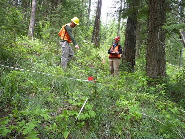
Spatially explicit information about forest stand-level attributes across all land ownerships provide a valuable resource for informing forest assessments, management planning, and policy decisions. Patterns of forest structure and mosaics of stand ages across landscapes are largely driven by canopy disturbances caused by both natural events (e.g. wildfire, windstorms, flooding, insects, and disease) and human actions (e.g. harvest, thinning, and planting). These disturbance events impact stand boundaries, age, structure, and growth. The cause of change (e.g. harvest, fire, or insects) can also influence goods and services such as economic value, productivity, recreation opportunities, water quality, biodiversity, and forest resilience. We aim to leverage the long-running Landsat archive, advances in cloud computing resources, and additional ancillary data sets to map annual forest canopy cover and identify disturbance patterns by their agents of change across the Great Lakes Basins. These canopy cover and disturbance products will be incorporated into efforts that take a watershed perspective across all land ownerships, such as National Forest planning and the Great Lakes Restoration Initiative. This project will support improved forest stewardship and facilitate assessments of the impacts of changes in land use and land cover on watershed health and brook trout habitat.
CARBON MONITORING ACROSS THE WESTERN U.S. (1984-2020)
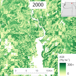 Project Title: A bottom-up, stakeholder-driven Carbon Monitoring System for regional biomass carbon dynamics: Phase II
Funder/Grant: NASA Carbon Monitoring Systems (#18-CMS18-0004)
Collaborating institutions: USDA Forest Service (PI – Dr. Andrew Hudak), University of Washington, Oregon State University, Washington State University, University of Minnesota
Associated Links: https://carbon.nasa.gov/cgi-bin/cms_projects.pl#current2018
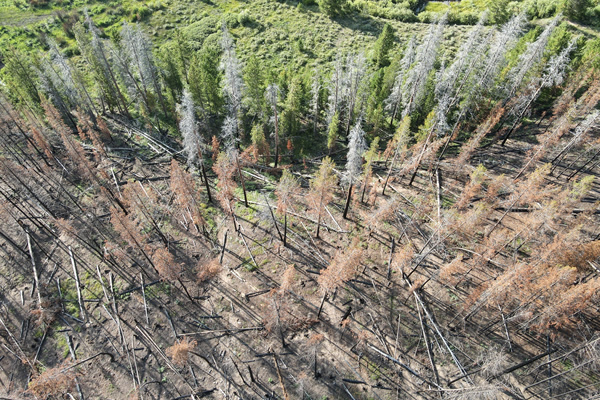
Accurately measuring forest carbon storage and flux is necessary for national carbon accounting programs and can improve our understanding of earth’s carbon cycle. As part of the NASA Carbon Monitoring Systems program, we’ve developed a method to integrate field data, multiple lidar collections, aerial imagery, and Landsat time series to provide estimates of forest and woodland aboveground biomass (AGB) across the western USA. Our workflow will yield annual AGB maps for the years 1985 – 2020 at a 30-m spatial resolution. These maps are aggregated to the county-level and compared to AGB estimates calculated from independently collected Forest Inventory and Analysis (FIA) field measurements. In response to stakeholder feedback, we also will create annual maps of basal area, timber volume, and surface fuels. We will further analyze the Landsat time series to identify and map forest disturbances including harvest, fire, insects, and stress (e.g., drought), which will provide insight into disturbance trends and post-disturbance recovery.
GEDI FOR WILDLIFE AND BIODIVERSITY ASSESSMENTS
Project Title: Evaluating GEDI data fusion tradeoffs for characterizing critical habitat components for animals and biodiversity assessments
Funder/Grant: NASA GEDI Program (#20-GEDIST20-0022)
Collaborating institutions: University of Idaho (PI – Dr. Kerri Vierling), University of Wyoming
Associated Links: https://gedi.umd.edu/
Animals respond to both horizontal and vertical patterns in forest structure. Habitat modeling efforts that include forest structure can therefore provide more accurate representations of habitat quality and biodiversity. Although airborne lidar is effective for characterizing vertical structure in forests, the limited spatial extent of this data creates challenges for studying wide-ranging animals. Spaceborne lidar, like GEDI, is likely to provide important vertical structural data at extents that will assist in 1) landscape management of critical animal habitat, and 2) identification of areas of high biodiversity. GEDI data additionally serves as a freely available reference data set for creating moderate resolution continuous maps of structure through fusions with additional publicly available remote sensing data. In this project, we will use modeling approaches to assess the trade-offs and value of using GEDI in combination with other freely available remote sensing products (e.g. Landsat annual spectral indices and disturbance history information and annual PALSAR mosaic products) to produce wall-to-wall GEDI-derived forest structure metrics that are important for animals across five western U.S. states (WA, OR, ID, WY, CO). We will focus our efforts on animal species that are of high management interest, such as those listed as Species of Greatest Conservation Need by state agencies, game species, and/or other medium-large sized carnivores of interest to managers. Publicly available avian and mammal location databases will be used to analyze the correspondence between species distributions and the structure attributes mapped with the aid of GEDI. Products from this project will include maps of forest metrics that can be incorporated in carbon assessments, maps of species distributions for animals of management interest, and maps representing different indices of diversity. Collectively, these maps can benefit land planning across multiple types of forest use and resources.
URBANIZATION DRIVEN LAND COVER LAND USE CHANGE IN AFRICA
![]() Project Title: The last urban frontier – Assessing drivers of urbanization and tradeoffs among social and ecosystem services associated with LCLUC in Africa
Project Title: The last urban frontier – Assessing drivers of urbanization and tradeoffs among social and ecosystem services associated with LCLUC in Africa
Funder/Grant: NASA Land Cover Land Use Change (#20-LCLUC2020-0006)
Collaborating Institutions: University of Pretoria – South Africa
Associated Links: https://lcluc.umd.edu/projects/last-urban-frontier-assessing-drivers-urbanization-and-tradeoffs-among-social-and-ecosystem
Urbanization continues to be one of the leading drivers of Land Cover Use Change (LCLUC) globally, although African countries appear to be at the forefront of these current urban expansion trends. In fact, predictions indicate that there will be more people living in cities in Africa in the next 30 years, than there are people living in cities right now around the world; with this increase in population growth it is also expected that we will see a 12-fold increase in urban land area. To date, the study of urbanization and its consequences and impacts has occurred at two very different scales and resolutions: (1) Large scale urbanization patterns (regional, national, or global) mapped at lower resolutions (≥30m pixels) , and; (2) small scale (city, neighborhood, parcel) urban heterogeneity mapped at high resolutions (<5m pixels). One approach is good for understanding urban growth, while the other method’s strength enables scientists to analyze landscape quality, human-environmental interactions, and tradeoffs in ecosystem services. This project aims to merge these divergent characterizations of urbanization so that we can capture large scale urbanization processes, while still quantifying the heterogeneity and quality of urban land uses across three African case study countries: Ethiopia, Nigeria, and South Africa. Furthermore, with this approach we can capture diverse multifunctional land uses within and around cities that provide a number of important ecosystem services to people near and far.
To accomplish this goal, we will develop a framework for multi-resolution remote sensing data fusions for a two-tiered LCLUC mapping approach which will dissect the urban agglomeration into more refined density and infrastructure driven urban classes with fine resolution identification of features and resources within classes. Spatial products will support the assessment of United Nations defined Sustainable Development Goal (SDG) indicators, identify hotspots of urbanization-driven LCLUC, and aid in sustainable urban planning for equitable access to services.
IMPACTS OF REWILDING AND URBANIZATION ON BIODIVERSITY
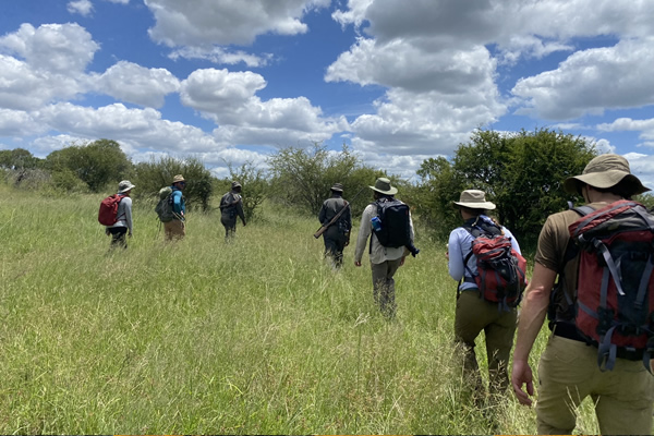
![]() Project Title: Biodiversity, connectivity, and ecological forecasting: applying NASA earth observation data to conservation management in the Greater Kruger National Park region, South Africa
Project Title: Biodiversity, connectivity, and ecological forecasting: applying NASA earth observation data to conservation management in the Greater Kruger National Park region, South Africa
Funder/Grant: NASA Ecological Forecasting (#20-ECOF20-0014)
Collaborating Institutions: University of Michigan, Arizona State University, South African National Parks, Organization for Tropical Studies South Africa, The Nsasani Trust
This project will develop an innovative forecasting framework for South African protected area managers, focusing on changing aspects of ecological connectivity. More particularly, we will be studying the edge interfaces of protected areas and rapidly expanding, semi-urban settlements, in a region that has been the subject of one of the largest forms of rewilding land conversion on the planet: South Africa’s Greater Kruger National Park (GKNP) region. A biodiversity hotspot, the GKNP region has on the one hand been subject to dramatic land use/land cover change (LCLUC) over three decades including fragmentation, habitat loss, human-wildlife conflict, and urbanization. On the other hand, it has also experienced extensive rewilding, including the widespread replacement of cattle farming with wildlife, the removal of fences to form larger contiguous protected areas, and the return of land rights to rural communities. These changes have produced a complex mosaic of varied land uses and conservation management regimes, including the world renowned Kruger National Park, private and municipal nature reserves, and communal lands under traditional authorities, bracketed by rapidly expanding settlements. Using a unique synthesis of earth observation and terrestrial data products, we will produce forecasting tools that will aid in understanding future habitat suitability and species dispersal, landscape change under new conditions of rewilding, and effective planning for new biodiversity corridors that include, rather than ignore, locally urbanizing zones.